The 3DEM application produces three dimensional terrain scenes and flyby animations from a wide variety of freely available data sources including:
- USGS - Digital Elevation Model (ASCII DEM) files
- USGS - Spatial Data Transfer Standard (SDTS DEM) files
- NASA - Shuttle Radar Topography Mission (SRTM) files
- LIDAR - Point Cloud (LAS) files
- USGS - Global 30 Arc Second Elevation Data Set (GTOPO30 DEM) files
- NOAA - Global Land One-km Base Elevation (GLOBE DEM) files
- NASA - Mars Orbiter Laser Altimeter (MOLA) files
- Any - topographic data file organized by rows and columns of elevation data
- XYZ - scattered point topographic data files

ArcGIS extension with geospatial analysis capabilities for mlitary applications.

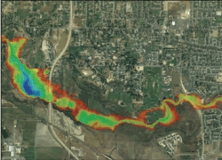
It is a program to view on 3D digital elevation maps mixed with data acquired


Comments